I'm very annoyed at how few GOOD photos and particularly maps or site maps there are of Orchomenos. Oh yes plenty of shots of the Tholos Tomb a few of the hellenistic citadel tower even fewer of the Byzantine church or theater but they're rather touristy and I was really looking for maps that show how orchomenos' location made it a dominant settlement in the area until the end of the Mycenaean area.
Pausanias' description suggests there should be a lot more visible above ground so it appears sadly that later residents very zealously recycled pagan buildings for newer works.
Here's what little I could find crop edit compile that may be of use?
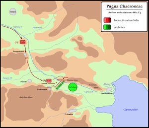
Actually a map of a battle but does show local topography and how Orchomenos could control local trade on the western side of the Copaic basin. If the old "acropolis" above Chaironeia was once an outpost for Minyan Orchomenos guarding the road nw?

Another view with a different interpretation of the shoreline.

Look at this before you try using Google Earth.
Only the Theatre is clearly visible on the Google Earth maps.
Both rivers have changed course.
The modern town site spreads eastwards.
Support me via PayPal.me/JulieVaux
Or PATREON PLEDGE ME
No comments:
Post a Comment