Saturday 23 May 2020

Orchomenos

ORCHOMENOS 

Orchomenos was the citadel of the Minyans who once controlled NW Boeotia. It is one of those sites that have been continuously occupied since the Neolithic and maybe longer and there is still a village there today. 


As you can see from the maps it was one of those sites beloved by Helladic builders, triangular or oval shapes, steep on some sides but with at least one section with a more gentle slope for access and water nearby, in this case rivers on both sides  that flowed into Lake Copais.

This meant when lake levels were high they could control water and road traffic and when water levels were low had a fertile valley to the north for farming with a permanent water supply and still control over roads. 

The Lake has gone and the wetlands drained once perhaps the second or third time or more times over the millennia  for farmlands today.  The rivers still flow. 

And as in so many parts of Greece stone echoes linger. 


Saturday 9 May 2020

GLA Citadel or something else?

#GLA is a #Mycenaean site that definitely does not not fit the pattern. Its modern  name is Albanian in origin. Some scholars think it was Hylai an unlocated settlement.

Yes it has walls and a ramp leading to a gateway but ...

This map shows Lake Copais at its hypothetical fullest extent. 
Personally I think it was smaller having studied the topography via Google Earth.


Here's another view showing GLA as an island.


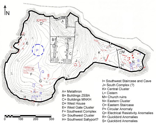
Note that the central buildings and the SE corner are walled off from the rest of the island.
Compare this to some of the other sites I've shown you.


I usually manage to find an decent aerial shot but in this  case ...
 
Frankly from what photos I've seen the modern island is mainly a mass of weeds inside a wall.

So why did the Mycenaeans put walls with a gate up on a remote island that would have been surrounded by water even in summer until the lake was drained in the 19th century? 

My best idea. While this is described as a citadel I think this was some kind of protected flood refuge for cattle and sheep and other stock or a supply storage depot. Recent research shows the Mycenaeans tried to drain at least part of the lake and reduce the problem of sudden water levels changes. 

The walls were added to keep herds up on the mound and maybe stop pilfering of supplies ?

This would also explain the four gates for quick access. You don't want to be having to move things to one gate if you're excavating from rising flood waters during spring thaw or after a dyke failure. You want to get to a higher level as quickly as possible. Those gates probably align with piers or causeways or roads buried under layers of silt deposit. I doubt however we're get full evidence of this any time soon as the local farmers would NOT be very happy if someone started tearing up their fields saying Hi we're looking for Mycenaean causeways!

A final thought if you were a Mycenaean looking to build a storage depot/ flood refuge and knew of a lump of rock too uneven for farming ... 


Saturday 2 May 2020

THEBES and the KADMEIA

#Thebes #mycenaeancitadels #Kadmeia

THEBES and the KADMEIA

THEBES did have Mycenaean walls and a rough outline can be seen if you look at aerial shots of the modern city but the Kadmeia has been reduced to a few walls and corners and odd remains of rooms or workshops that show up now and then when older buildings are torn down.

It may have been the leading power in Boeotia once but now its basically a country town.

It retains one Mycenaean feature the love of designers for adding walls to oval or triangular shaped sites often preexisting in the Helladic or even Neolithic


Here is an old map made by some one who has clearly based his map on descriptions of the Classical era city by Pausanias. We have no idea though if Thebes would had outer suburbs in the Mycenaean era?

The map also does not show that there were streams running along both the western and eastern sides of the Kadmeia or stress that Thebes was a junction for several ancient roads.


When Copais was a lake and wetland rather than a drained irrigated plain Thebes location would have allowed it to control roads and travel along the southern and eastern sides of the lake and access to the coast to the north east and block roads south east to Attica and the Isthmus.


Take a close look at this and then please also check Google Earth for recent aerial shots.

This cartographer felt the walls of Thebes covered a smaller area however at least he shows both streams and some roads and the Kadmeia area. 

Another location location location site. 

Hills and rivers and roads. 

Next time Minyan Orchomenos.